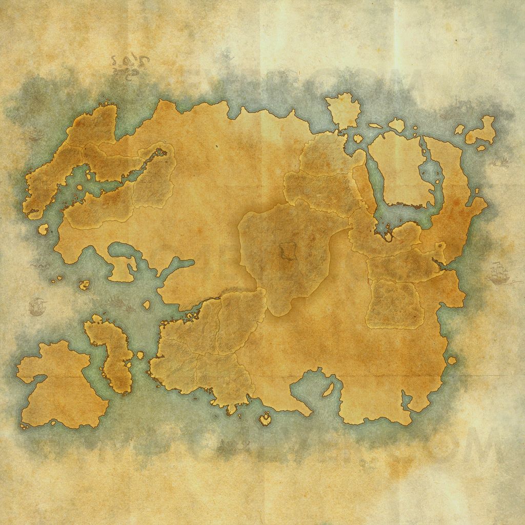
Tamriel world mapThe Elder Scrolls Online (TESO) Maps
Tamriel is a fictional continent where The Elder Scrolls Online is set. When the game first launches, there will be limited access to all areas, but over time with new expansions, game action will take place across the entire continent.
Tamriel contains nine regions: Cyrodiil, Black Marsh, Elsweyr, Hammerfell, High Rock, Morrowind, Skyrim, Summerset Isle, Valenwood.
Points of interest located on this map
Alik'r Desertmark on map
The Alik'r Desert is a region in northern Hammerfell. It is said that the Alik'r Desert is the largest of its kind in all of Tamriel and cities are typically situated around the edges. Though there are fertile fields on the coast near the capital city of Sentinel, it is the arid expanses of the interior that have captured the hearts of the rugged Redguards. The Alik'r is rich in mineral resources, but its fierce creatures and harsh terrain are daunting to most.
Auridonmark on map
The second largest of the Summerset Isles, Auridon has always served the High Elves as a buffer between their serene archipelago and the turmoil of Tamriel. The Altmer of Auridon have been hardened by generations of repelling invaders, pirates, and plagues.
Bangkoraimark on map
This region takes its name from its most famous feature, the Bangkorai Pass, which has served as High Rock's defense against the wild raiders of Hammerfell for countless generations. The uplands north of the pass and the desert to the south are both ruled from the port city of Evermore.
Cyrodiilmark on map
Cyrodiil is the center and capital of the Empire, home of the Imperials, and of the Emperor himself. Each player can enter the territory of Cyrodiil after reaching 10th level. Game has special "protection" for players with low levels. When such player enters Cyrodiil he receives temporary bonus of health, magicka and stamina. This bonus will increase its chances to survive. But the best PvP experience can be received after reaching highest level.
Deshaanmark on map
The fertile valleys of Deshaan are home to lush fungal forests, deep kwama mines, and broad pastures where netches and guar graze. But all pales before the magnificence of Mournhold, home of the Tribunal and capital of the Ebonheart Pact.
Eastmarchmark on map
One of the "Old Holds", Eastmarch was among the first regions of Skyrim settled by the Nords when they arrived from Atmora. Its capital, Windhelm, is the oldest continously-inhabited human settlement in Tamriel, and was founded by Ysgramor himself.
Glenumbramark on map
Glenumbra, the westernmost region of High Rock, contains the city-states of Daggerfall and Camlorn, the great cemetery of Cath Bedraud, and the wild areas of Hag Fen, Glenumbra Moors, and the forests of Daenia.
Grahtwoodmark on map
This region is the southern heart of the Wood Elves' great forest, and home to more of the gigantic graht-oaks than any other part of Valenwood. Its capital, now also the capital of the entire Aldmeri Dominion, is Elden Root.
Greenshademark on map
As the region of Valenwood farthest from all other realms, Greenshade's graht-oak forest is virtually pristine, the Tamriel jungle at its most primeval. Its capital is the trading port of Woodhearth.
Malabal Tormark on map
Malabal Tor is the northwest region of Valenwood, on the coast of the Abecean Sea and the Strid River estuary. Its capital is Silvenar, the spiritual home of all Wood Elves.
Reaper's Marchmark on map
Once known simply as Northern Valenwood, this region that borders Cyrodiil and Elsweyr has seen so much bloody warfare since the fall of the Second Empire that it's now known as Reaper's March, even to its battle-scarred inhabitants.
Rivenspiremark on map
This northwestern region of High Rock contains some of the province's most dramatic terrain, including towering, flinty crags, windswept moors, and narrow canyons. Many folk find the environment oppressive, even threatening.
Shadowfenmark on map
On the border with Morrowind, the Shadowfen region has had more contact with Tamrielic civilization than most of Black Marshâdue primarily to the activities of the Dunmeri slavers who once operated out of the city of Stormhold. Now the Argonians are back in charge.
Stonefallsmark on map
The ashfall from the volcanoes of the Velothi Mountains and from great Ash Mountain itself is Stonefalls' bane and benefit, fertilizing the soil where the land isn't too arid to grow crops. It was here that the recent invading army from Akavir met its bloody end.
Stormhavenmark on map
Situated at the head of the strategic Iliac Bay, Stormhaven is the geographic center of High Rock, and also the home of the great trading city of Wayrest, capital of the Daggerfall Covenant.
The Riftmark on map
Skyrim's southernmost hold has a relatively temperate climate, thanks to northern mountains that block the frigid gales of the Sea of Ghosts, and warming volcanoes in the Velothi Mountains to the east. Its capital is Riften, on the shores of broad Lake Honrich.
Bal Foyenmark on map
Bal Foyen, on the southern coast of Morrowind's Inner Sea, was a wild expanse of marshland until recently. Now much of it has been turned over to the Dark Elves' former Argonian slaves, who plant saltrice and herd guar in the former wastes.
Betnikhmark on map
Nine generations ago, the island of Betony was conquered by the Stonetooth Orcs, who renamed it Betnikh. A proud, self-reliant people, the Orcs fiercely protect their new home from incursion by outsiders. Betnikh is an island that lies off the south coast of Glenumbra in the province of High Rock. The island of Betnikh is currently controlled by the Orsimer.
Bleakrock Islemark on map
Bleakrock is an island off the northeast coast of Skyrim between Windhelm and Solstheim. The hardy Nords who inhabit Bleakrock are mostly farmers and fisherfolk. A small contingent of Pact soldiers keeps a sharp lookout for pirates and raiders. This is the starting area of the Ebonheart Pact. All members of this alliance begin their journey on this island.
Khenarthi's Roostmark on map
This island off the south coast of Elsweyr is named after the Khajiiti goddess of weather and the sky, who is usually represented as a great hawk. She finds many worshipers among the cat-folk's sailors and farmers, especially those who grow moon-sugar cane. Starting area of the Aldmeri Dominion. All members of this alliance begin their journey on this island.
Stros M'Kaimark on map
One of the first landfalls settled by the Redguards when they sailed east from their lost homeland of Yokuda, the island of Stros M'Kai is now a haven for freebooters, sea-rovers, and other nautical entrepreneurs who roam the Abecean Sea. Starting area of the Daggerfall Covenant. All members of this alliance begin their journey on this island.
References
The Cosmic Map (Mundus)
The Cosmic map is the farthest you can currently zoom out on your The Elder Scrolls Online map. It shows both Tamriel and Coldharbour.