Daggerfall Covenant alliance mapThe Elder Scrolls Online (TESO) Maps
The Daggerfall Covenant stretches over the provinces of High Rock, Hammerfell and Orsinium. Its capital is the city of Wayrest, built on two shores of the Bjoulsae River in High Rock.
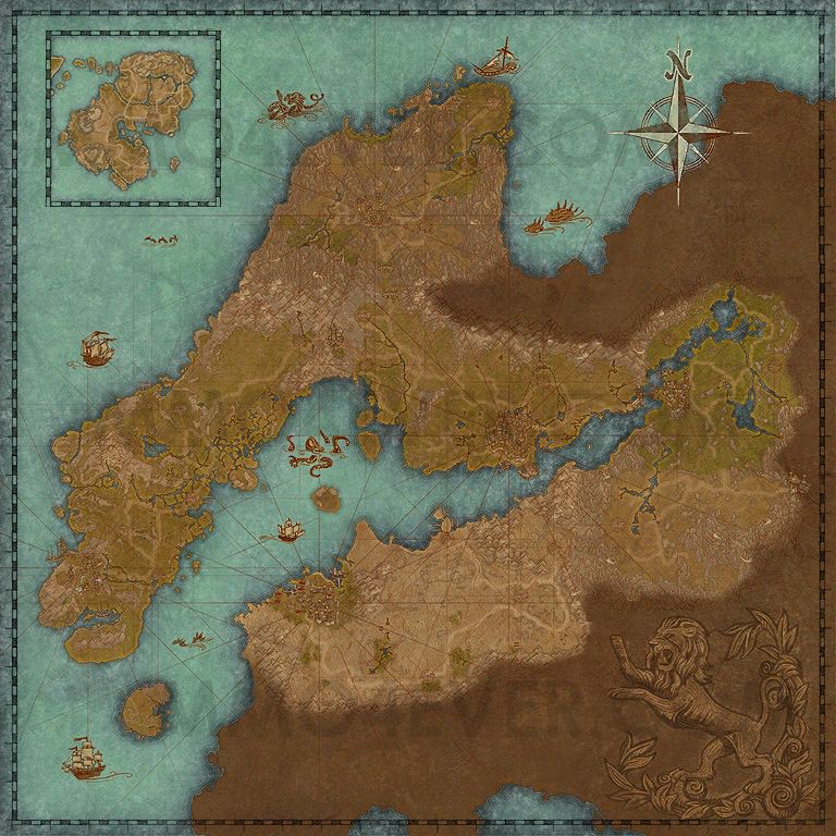
Points of interest located on this map
Betnikhmark on map
Nine generations ago, the island of Betony was conquered by the Stonetooth Orcs, who renamed it Betnikh. A proud, self-reliant people, the Orcs fiercely protect their new home from incursion by outsiders. Betnikh is an island that lies off the south coast of Glenumbra in the province of High Rock. The island of Betnikh is currently controlled by the Orsimer.
Alik'r Desertmark on map
The Alik'r Desert is a region in northern Hammerfell. It is said that the Alik'r Desert is the largest of its kind in all of Tamriel and cities are typically situated around the edges. Though there are fertile fields on the coast near the capital city of Sentinel, it is the arid expanses of the interior that have captured the hearts of the rugged Redguards. The Alik'r is rich in mineral resources, but its fierce creatures and harsh terrain are daunting to most.
Bangkoraimark on map
This region takes its name from its most famous feature, the Bangkorai Pass, which has served as High Rock's defense against the wild raiders of Hammerfell for countless generations. The uplands north of the pass and the desert to the south are both ruled from the port city of Evermore.
Glenumbramark on map
Glenumbra, the westernmost region of High Rock, contains the city-states of Daggerfall and Camlorn, the great cemetery of Cath Bedraud, and the wild areas of Hag Fen, Glenumbra Moors, and the forests of Daenia.
Rivenspiremark on map
This northwestern region of High Rock contains some of the province's most dramatic terrain, including towering, flinty crags, windswept moors, and narrow canyons. Many folk find the environment oppressive, even threatening.
Stormhavenmark on map
Situated at the head of the strategic Iliac Bay, Stormhaven is the geographic center of High Rock, and also the home of the great trading city of Wayrest, capital of the Daggerfall Covenant.
Stros M'Kaimark on map
One of the first landfalls settled by the Redguards when they sailed east from their lost homeland of Yokuda, the island of Stros M'Kai is now a haven for freebooters, sea-rovers, and other nautical entrepreneurs who roam the Abecean Sea. Starting area of the Daggerfall Covenant. All members of this alliance begin their journey on this island.
References
Tamriel (Political Map)
Political map of Tamriel in the Second Era, showing the three alliances (Daggerfall Covenant, Ebonheart Pact, Aldmeri Dominion) and Imperial territory (Cyrodiil), as seen in The Elder Scrolls Online.